Category:Wayfarer's Walk
Jump to navigation
Jump to search
footpath in England  | |||||
| Upload media | |||||
| Instance of |
| ||||
|---|---|---|---|---|---|
| Location | Hampshire, South East England, England | ||||
| Length |
| ||||
| Terminus | |||||
 | |||||
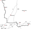
The Wayfarer's Walk is a long distance footpath in England from Walbury Hill, Berkshire to Emsworth, Hampshire.

Subcategories
This category has the following 2 subcategories, out of 2 total.
B
- Brown Candover War Memorial (1 F)
M
- The Manor House, Droxford (2 F)
Media in category "Wayfarer's Walk"
The following 198 files are in this category, out of 198 total.
-

-
 Alresford Golf Course - geograph.org.uk - 869257.jpg 640 × 427; 115 KB
-
 B3046 approaching Crooked Billet - geograph.org.uk - 329367.jpg 640 × 479; 138 KB
-
 Betty Mundy's Bottom - geograph.org.uk - 96569.jpg 640 × 427; 149 KB
-

-
 Byway on Great Litchfield Down - geograph.org.uk - 361768.jpg 640 × 477; 91 KB
-

-

-
 Cut Bridge, Cutts Arch, Soberton - geograph.org.uk - 237665.jpg 640 × 427; 135 KB
-
 Derelict barn on Abbotstone Down - geograph.org.uk - 304498.jpg 640 × 427; 125 KB
-
 Downland, Combe - geograph.org.uk - 763919.jpg 640 × 480; 125 KB
-
-
 Dummer House from Wayfarer's Walk - geograph.org.uk - 952007.jpg 640 × 480; 93 KB
-
 Exton, King's Copse, Betty Mundy's Bottom.jpg 3,000 × 1,995; 2.81 MB
-
 Farmland to the south of Lomer Farm - geograph.org.uk - 391530.jpg 640 × 480; 69 KB
-
-
 Fields above Betty Mundy's Bottom - geograph.org.uk - 391525.jpg 640 × 480; 103 KB
-
 Flint cairn on Ladle Hill - geograph.org.uk - 306651.jpg 640 × 480; 117 KB
-
 Footbridge - geograph.org.uk - 358099.jpg 640 × 427; 134 KB
-

-
 Footpath on Abbotstone Down - geograph.org.uk - 304513.jpg 640 × 427; 145 KB
-
 From the Wayfarer's Walk Hambledon - geograph.org.uk - 1268271.jpg 640 × 480; 194 KB
-

-

-
-

-

-
-

-
 From the Wayfarer's Walk near Hambledon - geograph.org.uk - 1268493.jpg 640 × 480; 215 KB
-
 From the Wayfarer's Walk near Hambledon - geograph.org.uk - 1268494.jpg 480 × 640; 204 KB
-

-

-
 George House, East Street - geograph.org.uk - 934096.jpg 640 × 480; 66 KB
-

-

-
 Kirby House - geograph.org.uk - 925126.jpg 640 × 480; 86 KB
-

-

-
 Looking towards White Hill and The Warren - geograph.org.uk - 473510.jpg 483 × 640; 118 KB
-

-
 On the Test Way near Buttermere - geograph.org.uk - 243744.jpg 640 × 480; 139 KB
-

-
 Path to the pub, Langstone, Hampshire - geograph.org.uk - 1721446.jpg 2,592 × 3,872; 2.7 MB
-
 Pit (dis) - geograph.org.uk - 360480.jpg 640 × 477; 123 KB
-
 Pond next to Wayfarers walk - geograph.org.uk - 1269193.jpg 640 × 480; 206 KB
-
 Prite Lane, Wayfarer's Walk, Tichborne - geograph.org.uk - 329507.jpg 640 × 427; 125 KB
-

-
 Row of beech trees on the Wayfarer's Walk - geograph.org.uk - 490866.jpg 481 × 640; 164 KB
-

-
 Stargrove - geograph.org.uk - 62433.jpg 640 × 480; 142 KB
-

-
 Stubbington Down - geograph.org.uk - 173589.jpg 640 × 480; 135 KB
-
 Swarraton Farm - geograph.org.uk - 303045.jpg 640 × 427; 118 KB
-
 Swarraton Farm House - geograph.org.uk - 303040.jpg 640 × 558; 168 KB
-
 The Beeches, Betty Mundy's Bottom - geograph.org.uk - 391485.jpg 480 × 640; 157 KB
-
 The Beeches, Betty Mundy's Bottom - geograph.org.uk - 391490.jpg 480 × 640; 153 KB
-
 The Ox Drove - geograph.org.uk - 360415.jpg 640 × 477; 155 KB
-
 The Tide's in at Langstone. - geograph.org.uk - 176540.jpg 640 × 439; 99 KB
-
 The Wayfarers Walk at Western Parade - geograph.org.uk - 1282421.jpg 640 × 480; 89 KB
-
 Track between Lomer Farm and Wind Farm - geograph.org.uk - 391322.jpg 480 × 640; 108 KB
-

-
 Track junction - geograph.org.uk - 360437.jpg 640 × 477; 143 KB
-
 Trig Point 5548 Pilot - geograph.org.uk - 530887.jpg 640 × 480; 119 KB
-
 Upper Lamborough Lane - geograph.org.uk - 947263.jpg 640 × 455; 110 KB
-
 Upper Woodcott Down - geograph.org.uk - 360446.jpg 640 × 477; 107 KB
-

-
 View of Hambledon, Hampshire, UK, from Speltham Hill, 2009.jpg 6,104 × 1,984; 10.15 MB
-

-
 Village Hall, Droxford - geograph.org.uk - 592412.jpg 640 × 427; 124 KB
-
 Walking the dogs - geograph.org.uk - 825582.jpg 640 × 480; 80 KB
-
 Walking the dogs - Wayfarer's Way - geograph.org.uk - 830708.jpg 640 × 480; 82 KB
-
 Wayfarer's Walk - geograph.org.uk - 1270747.jpg 640 × 480; 104 KB
-
 Wayfarer's Walk - geograph.org.uk - 1729308.jpg 640 × 480; 89 KB
-
 Wayfarer's Walk - geograph.org.uk - 355742.jpg 640 × 427; 100 KB
-
 Wayfarer's Walk - geograph.org.uk - 501978.jpg 640 × 480; 59 KB
-
-
 Wayfarer's Walk approaching Cheriton Mill - geograph.org.uk - 329472.jpg 640 × 427; 107 KB
-
 Wayfarer's Walk at B3046 - geograph.org.uk - 329236.jpg 640 × 427; 192 KB
-
 Wayfarer's Walk at Spy Bush Plantation - geograph.org.uk - 303052.jpg 640 × 427; 153 KB
-
 Wayfarer's Walk at Walbury Hill - geograph.org.uk - 1534274.jpg 427 × 640; 179 KB
-

-

-

-

-

-

-
 Wayfarer's Walk Hambledon - geograph.org.uk - 1268245.jpg 640 × 480; 177 KB
-
 Wayfarer's Walk Hambledon - geograph.org.uk - 1268257.jpg 640 × 480; 208 KB
-
 Wayfarer's Walk near East Hoe Manor - geograph.org.uk - 1269349.jpg 640 × 480; 153 KB
-
 Wayfarer's Walk near East Hoe Manor - geograph.org.uk - 1269355.jpg 640 × 480; 159 KB
-
 Wayfarer's Walk near East Hoe Manor - geograph.org.uk - 1269529.jpg 640 × 480; 155 KB
-
 Wayfarer's Walk near Hambledon - geograph.org.uk - 1268291.jpg 640 × 480; 204 KB
-
 Wayfarer's Walk near Swarraton Farm - geograph.org.uk - 303048.jpg 640 × 427; 129 KB
-
 Wayfarer's Walk on Stubbington Down - geograph.org.uk - 361158.jpg 640 × 477; 112 KB
-
 Wayfarer's Walk passes Lone Barn House - geograph.org.uk - 353083.jpg 640 × 427; 239 KB
-

-
 Wayfarer's Walk south of Shere Copse - geograph.org.uk - 1270757.jpg 640 × 480; 174 KB
-
 Wayfarer's Walk south of Shere Copse - geograph.org.uk - 1270760.jpg 640 × 480; 156 KB
-
 Wayfarer's Walk south of Shere Copse - geograph.org.uk - 1270804.jpg 640 × 480; 155 KB
-
 Wayfarer's Walk south of Shere Copse - geograph.org.uk - 1270812.jpg 640 × 480; 150 KB
-
 Wayfarer's Walk turns at crosstracks - geograph.org.uk - 1012438.jpg 640 × 360; 91 KB
-
 Wayfarer's Walk Waymark - geograph.org.uk - 947294.jpg 640 × 455; 91 KB
-
 Wayfarer's Walk, Droxford - geograph.org.uk - 592486.jpg 427 × 640; 216 KB
-

-

-

-
 Wayfarers Walk approaching Preshaw Wood - geograph.org.uk - 391500.jpg 480 × 640; 107 KB
-

-

-
 Wayfarers Walk Map Section 1.png 1,512 × 780; 82 KB
-
 Wayfarers Walk Map Section 2.png 1,404 × 1,956; 168 KB
-
 Wayfarers Walk Map Section 4.png 1,168 × 1,500; 116 KB
-
 Wayfarers Walk Map Section 5.png 746 × 1,200; 85 KB
-
 Wayfarers Walk Map Section 6.png 1,200 × 1,100; 68 KB
-
 Wayfarers walk marker.jpg 1,425 × 1,425; 356 KB
-
 Wayfarers Walk path at Warblington Church - geograph.org.uk - 680946.jpg 640 × 480; 108 KB
-
 Wayfarers Walk, Droxford - geograph.org.uk - 685892.jpg 640 × 438; 83 KB
-
 A34 crossing - geograph.org.uk - 361697.jpg 640 × 477; 98 KB
-
 A34 crossing - geograph.org.uk - 361715.jpg 640 × 477; 100 KB
-
 At Head of White Lane - geograph.org.uk - 697809.jpg 640 × 480; 77 KB
-
 Barn at Lomer Farm - geograph.org.uk - 53212.jpg 640 × 440; 71 KB
-
 Beeches by the Wayfarers' Walk - geograph.org.uk - 307227.jpg 640 × 480; 132 KB
-
 Betty Mundy's Cottages - geograph.org.uk - 96575.jpg 640 × 427; 207 KB
-
 Breach Farm Cottages - geograph.org.uk - 376419.jpg 640 × 477; 81 KB
-

-
 Church Lane, Brown Candover - geograph.org.uk - 353037.jpg 640 × 427; 192 KB
-
 Copse Lane, Brown Candover - geograph.org.uk - 302798.jpg 640 × 427; 157 KB
-
 Copse near Rabbit Pit Farm - geograph.org.uk - 62423.jpg 640 × 480; 160 KB
-
 Downland, East Woodhay - geograph.org.uk - 762435.jpg 640 × 480; 137 KB
-
 Downland, East Woodhay - geograph.org.uk - 763916.jpg 640 × 480; 162 KB
-
 Entrance to Dummer Grange - geograph.org.uk - 376401.jpg 640 × 477; 142 KB
-
 Estate Road from Dummer Grange - geograph.org.uk - 376407.jpg 640 × 477; 95 KB
-

-
 Farmland on Hare Warren Down - geograph.org.uk - 305515.jpg 640 × 480; 143 KB
-
 Farmland SE of Breach Farm - geograph.org.uk - 353361.jpg 640 × 427; 129 KB
-
 Farmland, Ladle Hill - geograph.org.uk - 305569.jpg 640 × 480; 131 KB
-
 Field east of Ladle Hill - geograph.org.uk - 667718.jpg 640 × 480; 105 KB
-
 Fields and Woodland near Bottomstead Farm - geograph.org.uk - 62399.jpg 640 × 480; 132 KB
-

-
 Fields near East Woodhay - geograph.org.uk - 62397.jpg 640 × 480; 152 KB
-
 Fine walking country - geograph.org.uk - 360489.jpg 640 × 477; 90 KB
-
 Freemantle Farm - geograph.org.uk - 697814.jpg 640 × 480; 67 KB
-
 Gallops, Watership Down - geograph.org.uk - 305483.jpg 640 × 480; 146 KB
-
 Great Litchfield Down - geograph.org.uk - 305952.jpg 640 × 480; 176 KB
-
-
 Hidden house - geograph.org.uk - 376392.jpg 477 × 640; 132 KB
-
 Lack of users on the Wayfarers Walk - geograph.org.uk - 639857.jpg 640 × 480; 44 KB
-
 Ladle Hill - geograph.org.uk - 305927.jpg 640 × 480; 115 KB
-

-
 Looking at Beacon Hill - geograph.org.uk - 360552.jpg 640 × 477; 79 KB
-

-

-
 Looking West along Watership Down - geograph.org.uk - 361229.jpg 640 × 477; 98 KB
-
 Looking westwards on the Wayfarers - geograph.org.uk - 640136.jpg 640 × 480; 29 KB
-
 Meadham Lane - geograph.org.uk - 173645.jpg 640 × 480; 163 KB
-
 Monument to Geoffrey de Havilland - geograph.org.uk - 476480.jpg 640 × 427; 156 KB
-

-
 Oak Tree along Wayfarer's Walk - geograph.org.uk - 62398.jpg 640 × 480; 161 KB
-
 On Cannon Heath Down - geograph.org.uk - 361217.jpg 640 × 477; 89 KB
-
 Pasture south of Brown Candover - geograph.org.uk - 302796.jpg 640 × 427; 147 KB
-
 Path junction above Kingsclere - geograph.org.uk - 361089.jpg 640 × 477; 104 KB
-
 Plantation on Becket's Down - geograph.org.uk - 353106.jpg 640 × 427; 155 KB
-
 Road to Lone Barn House - geograph.org.uk - 353084.jpg 640 × 427; 243 KB
-
 Shallow valley north of Kilmeston - geograph.org.uk - 439246.jpg 640 × 427; 120 KB
-
 Sheep in field near the church, Kilmeston - geograph.org.uk - 438337.jpg 640 × 427; 137 KB
-

-
 Start walking - geograph.org.uk - 361156.jpg 640 × 477; 115 KB
-

-
 The Ox Drove - geograph.org.uk - 360372.jpg 640 × 477; 126 KB
-
 The southern flank of Beacon Hill - geograph.org.uk - 476486.jpg 640 × 396; 61 KB
-
 Totford Farm seen from Wayfarer's Walk - geograph.org.uk - 302788.jpg 640 × 437; 138 KB
-
 Towards Tidley Hill - geograph.org.uk - 376390.jpg 640 × 477; 108 KB
-
 Unnamed Beech Wood on Becket's Down - geograph.org.uk - 353108.jpg 640 × 427; 147 KB
-
 View from Rabbit Warren - geograph.org.uk - 360461.jpg 640 × 477; 93 KB
-

-
 Wayfarer's Walk - geograph.org.uk - 62417.jpg 640 × 480; 213 KB
-
 Wayfarer's Walk - geograph.org.uk - 62419.jpg 640 × 480; 146 KB
-
 Wayfarer's Walk - geograph.org.uk - 697839.jpg 640 × 480; 132 KB
-
 Wayfarer's Walk above Totford - geograph.org.uk - 302787.jpg 640 × 427; 148 KB
-

-
 Wayfarer's Walk approaching Totford - geograph.org.uk - 302883.jpg 640 × 427; 155 KB
-

-
 Wayfarer's Walk climbing Becket's Down - geograph.org.uk - 353103.jpg 640 × 427; 159 KB
-

-

-

-
 Wayfarer's Walk near East Woodhay - geograph.org.uk - 62396.jpg 640 × 480; 207 KB
-

-

-
 Wayfarer's Walk north of Lone Barn House - geograph.org.uk - 353089.jpg 640 × 427; 207 KB
-
 Wayfarer's Walk north of St Clair's Farm - geograph.org.uk - 96553.jpg 640 × 336; 118 KB
-
 Wayfarer's Walk on Becket's Down - geograph.org.uk - 353212.jpg 640 × 355; 127 KB
-
 Wayfarer's Walk south of Breach Farm - geograph.org.uk - 353347.jpg 427 × 640; 229 KB
-
 Wayfarers Walk at White Hill - geograph.org.uk - 60607.jpg 640 × 480; 73 KB
-
 Wayfarers Walk path at Langstone - geograph.org.uk - 688267.jpg 640 × 480; 171 KB
-
 Wayfarers Walk through wheat fields - geograph.org.uk - 211485.jpg 640 × 480; 252 KB
-
 Wayfarers' Walk on Ladle Hill - geograph.org.uk - 361818.jpg 640 × 477; 117 KB


_-_geograph.org.uk_-_360480.jpg)


